Advanced Exploration Techniques and Services

Contact

As a leading international mining and exploration consultancy, we offer a comprehensive range of expert services tailored to meet your project needs. With over 25 years of industry experience, our team is equipped to handle everything from exploration planning to mine development. Explore our services below to discover how Dex Geoscience can support your next venture.

  • 3d design of the project

    Slide title

    Write your caption here
    Button

Dex Geoscience Discoveries

Dex consulting has been involved in successful exploration projects across Western Australia such as the discovery of a 40,000oz gold deposit south of Marvel Loch in 2010, and the pegging of the "Austin" VMS deposit on vacant ground near Meekatharra in 2006. During 2018 the L Channel diamond deposit was discovered for IBDH draining the Ellendale diamond field.

Dex was responsible for the re-interpretation of the "Austin" deposit historic drilling whilst consulting to Mercator Gold, then used historic geophysical data to provide a new 3D geological interpretation. Originally named "Ridgeback" by CRA in the early 1990's, the magnetic core was later drilled with significant VMS Copper mineralisation discovered adjacent to the historic drilling.
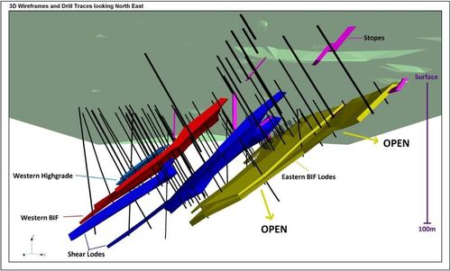
Visualisation of 3D drill holes through resource wireframes & geophysical models are skills which Dex Geoscience offers. The 3D drilling display examples are Dex 2010 and 2006 discoveries.
Dex Geoscience is often ahead of the field. A recent example was Dex consultants pegging 270 sq. km of vacant ground in the Fraser Range during 2011. This exploration ground was only 18km away from the 2012 "Nova" copper - nickel discovery and some of the hottest exploration ground in Australia in 2012.

Dex Geoscience Consulting

Mining and Exploration Specialist

Drill hole targetting using Aircore, RC & Diamond drill rigs also requires track permit and drill permit application management. Underground mineral lode targetting using underground diamond rigs, geophysics, resource estimation management, tenement management, historic data research and drilling database management are offered by Dex Geoscience.

  • More

    From exploration through to mining, the company operates Mapinfo GIS software, Encom Discover geology software and Encom Profile Analyst 3D geophysical display software. The company has experience with remote sensing imagery and specialises using ER Mapper (Erdas Imagine) software. The ER Mapper software is leased as required to produce .ecw imagery files to load into GIS software as base maps.

    Animations or 3D fly-through movies can be produced and often use a mineral deposit wireframes combined with 3D historic & planned drilling through geophysical target models, produced from surface or underground viewpoints. The company often designs and implement GIS work flows, can design shipping and trucking routes, can design ship loaders, can design mine infrastructure layouts, port dredging assessments, environmental permitting for drilling and native title management.

    Local grid transformations and affine to non-standard datum / projections are essential in the mining industry to dig your holes in the right place, although few mining specialists understand custom datum and projections and datum / projection's in countries that are not well referenced.

    GIS and cartographic skill-sets include large format A0 map production as hardcopies or pdf's, mining conference poster presentations, geophysical data processing, geophysical or geochemistry data imaging and interpretation, geological map production, map sheet index base map layouts, Mapinfo workspace configuration on servers for mining companies and drill hole databases creation from a number of industry standard templates.

    The company has extensive experience with ARC-GIS software systems as well as Mapinfo, for example an installation of a Geological Survey's ARC-IMS server which linked the state wide geoscience datasets with geophysical Image Web Server images and tenement database management systems.

    Dex Geoscience utilises Microsoft software to produce conference presentations using Microsoft Power Point (can embed 3D fly-through animations), mining & exploration production schedules using Microsoft Project, large format poster displays for conferences using Microsoft Publisher, website development using Microsoft Expressions Web 4, and geochemical / drilling database development using Microsoft Excel and Access.

Dex Geoscience Research

Published AIG 2011
Global Expansion from Density Decay
There will always be contradicting evidence to explain why the globe is variable in size or why it is fixed in size. But if the globe was smaller in size, then what other geophysical reasoning could explain such expansion? The idea of planet expansion is not new, and the ideas represented in this brief are not new either.

  • More

    Using both a combination of radioactive decay and density reduction, an attempt will be made to simplify how planets could have been smaller around formation.

    Everyone understands the largest influence on planet size is gravity. Gravity controls the distribution of elements and molecules, meaning the heaviest particles are pulled into the core. The lighter elements resulting from this process are therefore pushed to the outer planet and accumulate over time. Other planets and galaxies will influence their gravity fields on ours too, controlling the orbit distance around the sun. Gravity also controls the orbit distance of our sun around the galaxy, but these influences on our planets temperature (gas / solid / liquid phases) are not well understood currently.

    Excluding gravity influences from other stars, there are two prime causes for planet expansion being planet mass increase or planet density decrease. Firstly, planet mass increase is the simplest to describe as every planet (including the earth) attracts space dust, meteorites and small moons via their larger gravity fields, explaining some of the size increase but not all of the size increase. Geochemical fractionation is a result of the gravity field, with the chemical periodic table ordered using mass number. The elements in the atmosphere are the lightest in mass and elements in the crust being a mixture.

    The densest elements (radionuclide’s) are in the core powering the planet through heat production from radiation, so the core is the prime candidate for the expansion source.


    The more complex to explain is core density reduction through fission decay. If fission radioactive reactions (splitting of particles) outweighed fusion reactions (collision of particles) under the cores extreme gravity conditions, then over time the core should probably lose mass as heat. Fission decay over time means 1 dense molecule would be split into 2 lighter molecules plus radiation emissions (+heat) in some decay chains.

    “Density decay” of every planet through radioactive decay is not a new concept, but has not been explained well in terms of a potential volume expansion. The core is an accumulation of the densest elements, and radioactive decay over time will produce lighter elements. These are pushed to the outer core as their density has decreased through “Mass defect” energy equations.

    This means that although the overall mass number of the two newly created elements when added together is the same as the original mass number (i.e. mass cannot be destroyed), because of the radiation energy created there may be a density reduction in the core via nuclide particle redistribution.

    If planets do expand over time from density decay within their core, then the sequential order would be:


    1) Core decay is source for mantle magma

    2) Magma convection is mass fractionation

    3) Plate tectonics are result of fractionation

    4) Subduction is effect of planet expansion

Dex Geoscience Mine Experience

  • working site area

    Slide title

    Write your caption here
    Button

Mines previously worked on include:
•   WA - Marvel Loch Open Cut and Underground Gold mines
•   WA - Meekatharra Open Cut and Underground Gold Mines
•   WA - Radio Hill Open Cut and Underground Nickel Mine
•   WA - Whundo Open Cut Copper Mine
•   QLD - Bundarra Underground Copper Mine
•   QLD - Ben Lomond Uranium / Molybdenum Mine
•   WA - Koolan Island Open Cut Iron Ore Mine
•   WA - The Ridges Open Cut Iron Mine
•   WA - Bulong open cut Lateritic Nickel mine
•   Kenya - Macalder Open Cut / Underground Copper Mine

Dex Geoscience Deposit Experience

Deposits previously worked on include:
•   WA - Lake Maitland and Kintyre Uranium deposits
•   QLD - Maureen Uranium deposit
•   NT - Angela and Pamela Uranium deposits
•   PNG - Wowo Gap Lateritic Nickel Deposit
•   WA - Ellendale and Nabberu Diamondiferous Pipes
•   Greenland - Iron ore discovery
•   South Korea - Uranium Deposit animations
•   South Africa - Bushveld area for PGE and diamonds

Our Experience

Exploration experience is extensive, and includes commodities such as REE, PGE, Potash, Tin, Manganese, Graphite, Tungsten, Silver, Lead, Zinc, Titanium and Sulphide.

The consultancy also practices Ethical Mining Protocol (EMP) which include policies such as:
•   No exploration operations in National Parks
•   No exploration in wildlife sanctuaries (i.e. polar bear)
•   No exploration in or around town sites (i.e. golf courses)

  • yellow and blue color helicopter flying

    Slide title

    Write your caption here
    Button

Contact us today to speak to international mining consultants in Perth, WA.

Contact